DB4IoT

Analyzing Vehicle Movement Data: Current Challenges and Future Promises

By |November 13th, 2018|

Eimar M. Boesjes, CEO, Moonshadow Mobile
Adrian Pearmine, National Director for Smart Cities & Connected Vehicles, DKS Associates
ITE Journal, November 2018

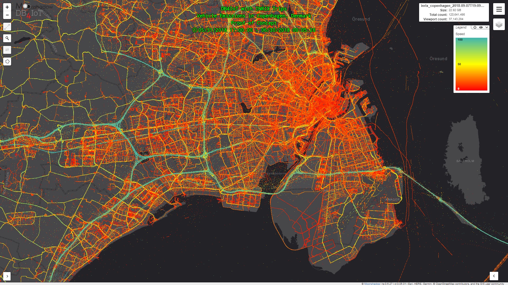
Transportation decisions are driven by data. In many cases, significant investment decisions from transportation planning and analysis have been based on limited data sets using traffic data collected over a period of a week or less. But, we know transportation demand and patterns are dynamic. Traffic varies daily as a result of incidents, special events, weather conditions, holidays and more. Traffic also varies from year-to-year based on factors such as the economy, changes in travelers’ choices, and new development. In […]

Deriving Greenhouse Gas Emissions Estimates from Connected Vehicle Data

By |October 31st, 2018|

Eimar M. Boesjes, CEO, Moonshadow Mobile
Joshua Skov, Industry Mentor, Lundquist College of Business, University of Oregon
October 26, 2018

What does the carbon footprint from transportation look like? In particular, how could you map it?

Typically, carbon footprinting exercises for local and regional jurisdictions deliver highly aggregated results. Even when the unit of analysis is geographic, the data is all about pie charts and tables. The results for New York City are…for all of New York City. Meaningful and important, but it leaves us missing something truly geographic in nature. Moonshadow Mobile recently completed a proof of concept (PoC) to derive greenhouse gas […]

DB4IoT with INRIX Trips: Generate Origin-Destination Matrices in Seconds

By |August 21st, 2018|

DB4IoT with INRIX Trips delivers the capability to generate Origin-Destination matrices from databases with hundreds of millions of waypoint records within seconds.  This makes generating O/D matrices an interactive process.  Users can change the time periods, date range or vehicle types and DB4IoT generates the O/D matrix automatically.  This video shows how quick and easy it is to generate an O/D matrix in DB4IoT with INRIX Trips.

DB4IoT, Moonshadow’s database engine for the Internet of Moving Things, was purpose-built for time-series geospatial data about moving objects (IoMT data). DB4IoT is faster and more efficient than traditional database solutions in delivering […]

Moonshadow Mobile Partners with INRIX to Deliver Powerful Travel Pattern Analytics Platform

By |June 4th, 2018|

Novi, MI – June 4, 2018 – Today, Moonshadow Mobile, Inc. announced a partnership with INRIX, the world leader in transportation analytics and connected car services, to incorporate INRIX Trips Reports into Moonshadow’s DB4IoT platform. The solution offers transportation agencies an intuitive, cloud- based origin-destination analytics platform for understanding the trips consumers and fleets make over time on maps, charts, graphs and animations.

“DB4IoT with INRIX Trips transforms and optimizes operations for departments of transport and public transit agencies, informs short- and long-term transportation planning and engineering efforts, and unleashes the potential of connected vehicle data,” said Eimar Boesjes, CEO at […]

DB4IoT Route Analyst GTFS Released for Three Agencies in Greater Seattle Area

By |November 30th, 2017|

Route Analyst GTFS has been released for the following three agencies in the Greater Seattle area; King County Metro (KCM), Pierce County and the Washington State Ferries. KCM provides public transit throughout the greater Seattle region servicing towns from Lake Forest Park and Bothell in the North to Kirkland, Redmond and Bellevue in the East and Burien, Tukwila, Renton, Federal Way and Auburn in the South. Pierce Transit covers the greater Tacoma area and the WA State Ferries link many of the islands in the Puget Sound and in the San Juan Islands.

These agencies make their schedule available as a […]

DB4IoT Route Analyst GTFS Released for RTD Denver

By |November 28th, 2017|

Moonshadow Mobile has released DB4IoT Route Analyst GTFS for the Regional Transportation District (RTD) in Denver, Colorado. The RTD provides public transit throughout the greater Denver region servicing towns from Longmont, Boulder and Lafayette in the North to Sheridan, Englewood, Aurora, Littleton and Centennial and all the way to Parker, CO, in the South.

The RTD makes its schedule available as a GTFS file whenever the schedule changes. The RTD also publishes the movement of all its buses and trains in real-time as a GTFS Real Time Vehicle Position file. Route Analyst GTFS tracks all vehicle movement live and retains all […]